At the beginning of February I signed up to walk a stretch of the/ John O'Groats Trail (JOGT) which is a coastal walking route from Inverness to John O' Groats - 147 miles passing through stunning coastal scenery and historical points of interest.

JOGT: STARTED FROM ONE MAN ON A WALK
What is now known as the John O' Groats Trail, started just only a few years ago in 2014. Of course, anyone could have walked the route before this, but it has only been in recent years that it has trail status, with work being done to cut back vegetation, install way-markers, and build stiles and bridges. If you have done long-distance walks like the West Highland Way or the somewhat gentler Great Glen Way, then there is less in the way of formal paths and tracks on some stages of the route.
We're fortunate to have close access to the trail in Wick. We live an easy walk away from Old Wick Castle which is one of the castles the route passes by. The JOGT trail has 14 stages, and we did the middle stretch (Duncansby to Skirza) of the final stage from Reiss to John O' Groats.
JOGT: STUNNING SCENERY
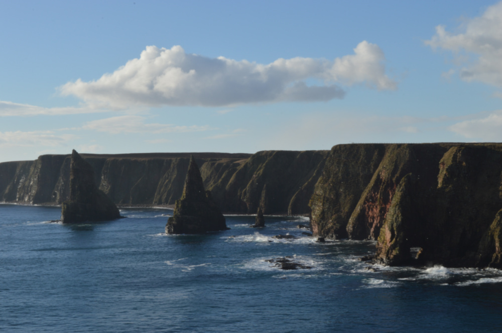
Despite other areas in Caithness seeing snow, it was gloriously clear when we arrived at Duncansby Head, and we had amazing views towards the Duncansby Stacks.
The cliff formations are amazing, especially when you can see the waves crashing into them.
As we looked north we couldn't help but feel smug as a band of snow passed over Orkney, while we still had blue sky!
I hadn't actually walked that close to the stacks before, and as you face them from the west, then southwest, their shapes appear completely different.

There is a wire fence on the cliff edge, but there are some places where you can climb down onto the shore, or get an alternative angle for your photos. I was quite close to the edge for taking this photo!
There are lots of Geos along the eastern Caithness coastline. A Geo is a long, narrow, steep-sided cleft formed by erosion in coastal cliffs, and we had visited Ellen's Geo before and also Whaligoe, which are further south of Wick.

JOGT: SEAL-SPOTTING
There were loads of Geo's on this section, and I can't remember many of the names. However, I remember Fastgoe because there was a huge group of seals on the rocks there. Even with my long lens, I couldn't get close-up shots because we were high up, but it was amazing to see such a big group (we counted 31). There was also the ruin where we sheltered for our lunch which everyone was ready for!
After lunch, the going got a little bit boggier, and of course, I got wet feet when I misjudged where there was wet ground (more than once!), but once they were wet, you just had to keep going, and I was just glad we were more than halfway through the route when it happened!

There was also lovely lichen everywhere, a sign of clean air found across much of Scotland.
As we approached Skirza Head we were much closer to the cliff edge and we had to take care as we walked along. There are other sections of the JOGT which are noted as being much more narrow so it is important to read the stage guides on the website as they do give valuable information on what to expect!
I had an excellent time out on the trail and I'm definitely going to be looking at doing some more of the route in future. Thanks to Jim the JOGT ranger for guiding our small group!